
Geographic Overview of Door County, Wisconsin
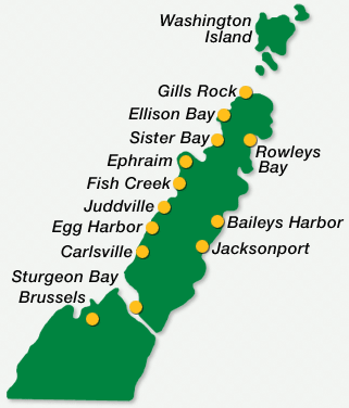
This simplified map illustrates the spatial distribution of communities along the Door County peninsula, including Washington Island. These locations highlight the region’s coastal alignment and provide a reference for understanding how settlement and infrastructure developed along Lake Michigan and Green Bay.
Northern Communities
- Washington Island: Located across Death’s Door Strait, this island holds historical significance due to early Scandinavian settlement and maritime activity.
- Gills Rock: Positioned at the northern tip of the peninsula, this area is historically connected to fishing and lighthouse navigation.
- Ellison Bay: A small, established community with natural access points to the Niagara Escarpment cliffs.
- Rowleys Bay: Situated near protected shoreline and forest preserves, often linked with natural exploration and recreation.
Central Communities
- Sister Bay: Centrally located along the western shore, this village serves as a mid-point hub between northern and southern towns.
- Ephraim: Known for preserved architecture and its connection to Moravian settlement patterns.
- Fish Creek: A cultural and geographic center of the peninsula, offering proximity to Peninsula State Park.
- Juddville: A small locality situated between Egg Harbor and Fish Creek, reflecting residential and rural land use.
- Baileys Harbor: Located on the eastern side, this town provides coastal access along Lake Michigan and is known for its proximity to lighthouses and natural sanctuaries.
Southern Communities
- Egg Harbor: Positioned along the bay side, this area includes residential zones, small commercial centers, and preserved waterfronts.
- Carlsville: Inland from the coast, this location represents agricultural and low-density development areas.
- Jacksonport: Located along the eastern shoreline, providing views of open lakefront and seasonal access points.
- Sturgeon Bay: The county’s largest urban center, located near the canal system connecting Green Bay to Lake Michigan. It includes industrial, residential, and administrative zones.
- Brussels: Located in the southwestern part of the country, known for its rural character and Belgian-American cultural heritage.
This map serves as a geographic reference for understanding how the peninsula is organized from north to south, reflecting both natural features and human settlement patterns. The layout also helps illustrate how proximity to water has influenced development, commerce, and conservation efforts throughout the region.
Door County and Its Extended Communities
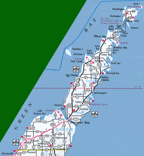
This map presents a detailed view of Door County, Wisconsin, showing both prominent and lesser-known communities, as well as natural features, transportation routes, and adjacent islands. The layout emphasizes the region’s geography, shaped by its position between Green Bay and Lake Michigan.
Northern Door County and the Islands
At the northernmost point, Washington Island is accessible by ferry and includes adjacent features such as Rock Island, Detroit Island, and Jackson Harbor. These islands contribute to Door County’s maritime identity and are located beyond Gills Rock, the last mainland village before crossing Death’s Door passage.
Coastal and Inland Communities
From north to south, the map illustrates a sequence of shoreline towns along both the bay and lake sides of the peninsula. These include:
- Ellison Bay, Sister Bay, Ephraim, and Fish Creek along Green Bay
- Rowleys Bay, Baileys Harbor, Moonlight Bay, and Jacksonport along Lake Michigan
Inland communities such as Carlsville, Institute, and Valmy appear between the two coasts. These locations are often surrounded by agricultural land, woodland preserves, or rural residential areas.
Southern Door County
Further south, the map includes Sturgeon Bay, the county’s largest city and administrative center. South of Sturgeon Bay are communities including Maplewood, Forestville, Rosiere, and Brussels, with Little Sturgeon Bay and Clay Banks positioned near the shoreline. These areas reflect a mix of agricultural, historical, and cultural settlement patterns.
Natural Features and Landmarks
The map also identifies notable natural and recreational sites, including:
- Peninsula State Park near Fish Creek
- Whitefish Dunes State Park near Valmy
- The Ridges Sanctuary near Baileys Harbor
- Sturgeon Bay Ship Canal and associated lighthouses
- Numerous bays, harbors, and escarpment cliffs shape the shoreline
Additionally, ferry routes, scenic byways, and hiking trail access points are visible, supporting a deeper understanding of how geography influences connectivity and land use.
Roadways and Transportation
Two main highways, Route 42 and Route 57, form the backbone of land-based travel through Door County. They split and reconverge around Sturgeon Bay, providing access to the region’s towns, parks, and coastal routes. The detailed labeling of roads and ferry lines shows how residents and visitors navigate the peninsula and its surrounding waters.
This map offers a comprehensive visual framework of Door County, reflecting its complex combination of coastal geography, inland terrain, historical communities, and ecological sites. It is well-suited for educational reference, regional planning, and geographic orientation.
Comments are closed